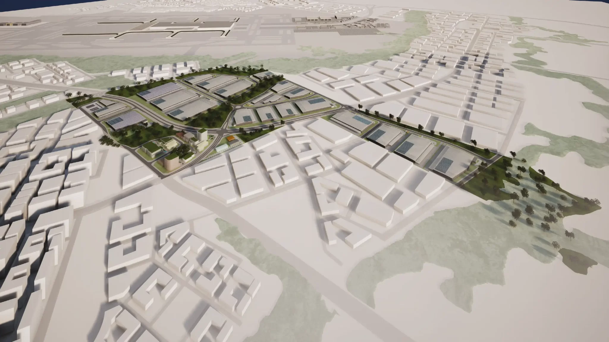
The NSW Government has approved a master plan unlocking over 500,000 square metres of employment floorspace near the future Western Sydney Airport. Located at 475 Badgerys Creek Road, Bradfield, the 50-hectare site will become a major industrial and logistics hub in the Aerotropolis Core.
Ingham Property Group prepared the IPG Badgerys Creek Road Master Plan (WSA_MP01), which received approval on 11 July 2025. This followed a detailed co-design process with government agencies and consultation with community and industry stakeholders.
Strategic Context
The site lies within the Western Sydney Aerotropolis, a key part of the Western Parkland City and a focus of NSW planning priorities. It sits along major planned infrastructure corridors, including the Eastern Ring Road, Fifteenth Avenue, and Bradfield Metro Link Road. These connections will enable efficient access to the Western Sydney Airport and nearby centres.
The Aerotropolis Core Precinct is set to become a high-order employment destination. It will support industries such as advanced manufacturing, logistics, and professional services. The IPG site is zoned for enterprise use under the Western Parkland City SEPP and identified as priority employment land.
Two land parcels form the site. Ingham Property Group owns Lot 100. Epsilon Distribution Ministerial Holding Corporation owns Lot 99, which contains an electrical substation. Development will focus on Lot 100, with staging planned around infrastructure constraints on Lot 99.
Master Plan Overview
The industrial master plan allows up to 507,050 square metres of gross floor area (GFA). It includes industrial and warehouse buildings, a mixed-use local centre, and amenity nodes. Key features include large-format lots, integrated stormwater basins, riparian corridors, and new public roads forming a logistics hub.
Pedestrian and cycling paths will connect employment areas to green corridors and future public transport. The master plan controls building heights, setbacks, deep soil zones, and landscaping through a tailored complying development code.
This code allows proposals that meet performance standards to proceed without development consent. It streamlines assessment and provides greater certainty for developers in this urban development precinct.

Master Plan by Urbis
Assessment and Co-Design Process
The proposal followed the Aerotropolis SEPP’s seven-stage master planning process. The proponent worked closely with the Technical Assurance Panel (TAP), a multi-agency advisory group led by the Department of Planning, Housing and Infrastructure.
Public exhibition occurred from 15 November to 13 December 2024. The department received 23 submissions—15 from government agencies and 8 from residents or landowners in Badgerys Creek and nearby areas.
In response, the proponent redesigned stormwater basins, reclassified roads, and increased deep soil zones. They also refined the complying development code to reflect agency feedback and align with Western Sydney Airport infrastructure planning.
Agency and Community Feedback
Transport for NSW flagged concerns about pedestrian access through industrial blocks. They recommended changes to improve connectivity and safety. They also called for future consultation on pedestrian links during detailed design.
Sydney Water requested continued involvement in stormwater infrastructure design, especially for regional detention basins. To meet this, the proponent modified retaining walls and drainage channels to improve access and landscape quality.
Liverpool City Council and Government Architect NSW gave detailed feedback on urban design, heritage, and infrastructure coordination within the Aerotropolis Core.
Community views varied. Some residents raised concerns about traffic, safety, and environmental impacts. Others supported economic development and the activation of local employment lands.
Infrastructure and Staging
The developer will stage the project in line with infrastructure delivery. Initial works will include earthmoving, road construction, and service installation to enable early subdivision and development near Western Sydney Airport.
Road hierarchy changes include reclassifying Road 07 and consolidating stormwater basins M12 and M13. These changes reduce retaining walls and improve pedestrian connections.
The GFA cap is 507,050 sqm. However, if development exceeds 407,920 sqm, the proponent must submit an updated Transport Management and Accessibility Plan (TMAP) for endorsement by Transport for NSW.
Developers must show that essential infrastructure—such as roads and active transport links—is operational before progressing each stage.
Project Team
- Developer: Ingham Property Group
- Planning consultant / Master planner: Urbis
- Architects: SBA, Site Image
- Traffic & transport engineers: TTPP
- Civil engineers / Stormwater design: AT&L
- Structural engineers: SDA Structures
- Acoustic engineers: Acoustic Logic
- Environmental & ecological consultants: JBA, Eco Logical
- Heritage & Aboriginal cultural consultants: Curio Projects, Yerrabingin
- Landscape architects: Northrop
- Surveying & geotechnical engineers: TSA Management