Mahers Lane Developments Pty Ltd has submitted a development application for a residential subdivision and associated civil works at Henry Lawson Drive and Mahers Lane, Terranora. Lodged with Tweed Shire Council on 19 December 2024, the proposal outlines plans to create 216 residential lots. It aims to address regional housing needs in response to population growth.
Development Overview
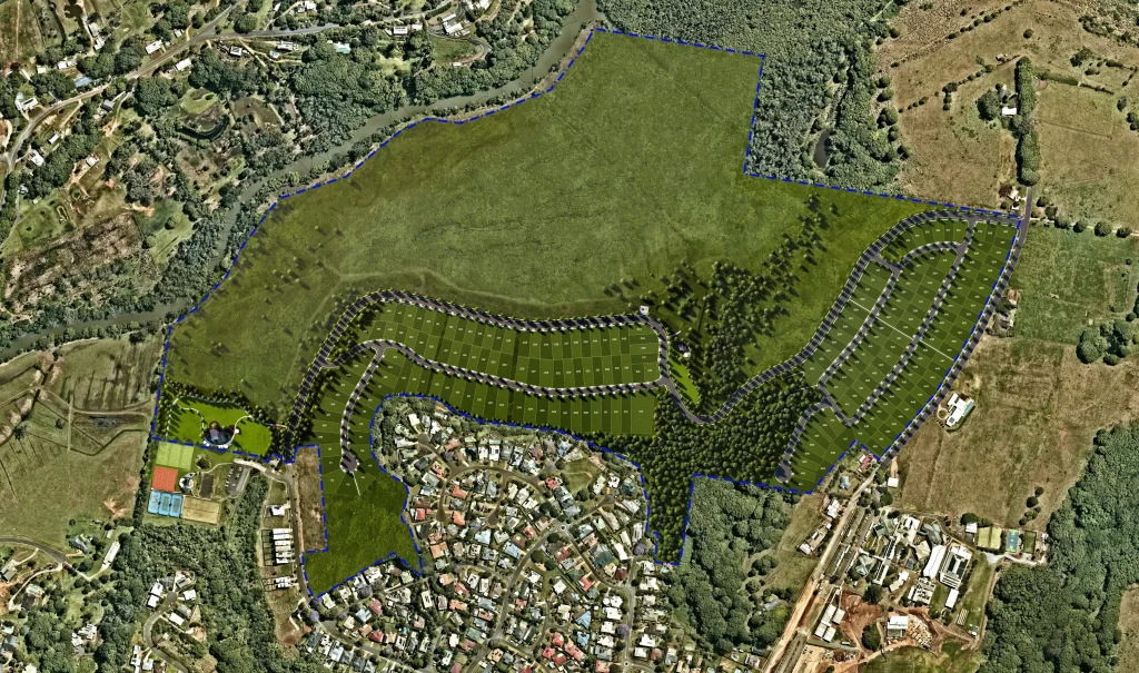
The project involves subdividing a 61.87-hectare site into 216 residential lots and one future development lot. The construction includes roads, sewerage infrastructure, and stormwater systems. Furthermore, land will be allocated for public reserves and environmental facilities. Importantly, the design integrates recreational areas and conservation zones to protect environmental features.
This development provides a response to increasing housing demand while maintaining a focus on environmental considerations. By combining residential, recreational, and environmental elements, the proposal aims to balance growth with sustainability.
Key Features of the Proposal
The development introduces several notable features, including:
- Residential Lots: The site will be subdivided to create 216 lots with infrastructure to support housing needs.
- Public Reserves and Open Space: The plan designates significant areas for recreation and conservation to enhance accessibility and promote environmental protection.
- Infrastructure Upgrades: Internal roads and utilities, including a sewer pump station and a stormwater management system, will support the residential lots.
- Environmental Conservation Measures: Strategies such as bioretention systems and vegetation buffers aim to protect wetlands and native flora.
Additionally, off-site works, such as road and pedestrian improvements, are part of the broader development plan. However, these will be addressed in separate applications.
Environmental and Planning Considerations
The proposal aligns with environmental regulations and local planning instruments, including the Tweed Local Environmental Plan (LEP) and Development Control Plans (DCP). Various technical studies ensure compliance while addressing potential impacts.
Stormwater Management:
The stormwater system will manage runoff effectively to reduce impacts on nearby wetlands. Bioretention basins will filter water, ensuring quality and quantity align with regulatory standards.
Traffic Impact:
Upgrades such as a proposed roundabout at Henry Lawson Drive will accommodate anticipated traffic increases. The internal road network is designed to meet council guidelines for safe and efficient access.
Biodiversity Conservation:
Retention of significant trees and offset planting will help minimise habitat loss. Conservation zones will ensure that native flora and fauna are protected.
Bushfire Mitigation:
Asset Protection Zones (APZs) and other measures will ensure compliance with bushfire safety standards. These zones will minimise risks to property and residents.
These considerations reflect efforts to manage potential impacts while ensuring the project aligns with statutory requirements.
Site History and Context
Historically, the site supported agricultural activities. Over time, it transitioned to residential zoning under the Tweed LEP. In 1987, the western precinct was zoned for village use. Later, in 2007, the eastern precinct became an urban release area. These changes highlight the long-term planning goals for the region.
The site features undulating terrain, ranging from low-lying areas near Duroby Creek to ridges in the southeast. Although parts of the land have been cleared for grazing, significant portions retain native vegetation and wetlands.
Adjustments to Previous Approvals
This proposal updates earlier approvals under S96/0066 for the Terranora Village Estate. Two significant adjustments include:
- Relocation of Open Space: Public reserves have been strategically relocated to improve recreational access and protect environmentally sensitive areas.
- Exclusion of Stage 17C: This stage has been removed, consolidating residential lots into other areas of the development.
These changes reflect updated planning priorities and aim to enhance the functionality and sustainability of the project.
Community Impacts
The development is expected to increase the local population, which will lead to higher demand for infrastructure and services. In response, the proposal includes road upgrades and enhanced utility networks. Public reserves and recreational areas are part of the design, offering benefits to both new and existing residents.
Project Team
The following organisations are leading the planning, design, and assessment of this development:
- Developer: Mahers Lane Developments Pty Ltd.
- Urban Planner and SEE Author: Zone Planning NSW Pty Ltd.
- Civil Engineering: Civil360.
- Stormwater Management: Biome.
- Ecological Assessment: JWA Ecological Consultants.
- Traffic Engineering and Noise Analysis: TTM Consulting.
- Arboriculture: Northern Tree Care.
- Bushfire Risk Assessment: Bushfire Risk.
- Cultural Heritage: Tweed Byron Local Aboriginal Land Council.
- Geotechnical Analysis: Butler Partners.
- Surveying: B&P Surveys.
- Socioeconomic Impact Assessment: Sarah George Consulting.
- Landscape Design and Visual Impact: Zone Landscape Architecture.
- Acid Sulfate Soil and Contamination Studies: HMC Environmental Consulting.
For more information, search the application number (S96/0066.22) on the Tweed Shire Council’s website.


